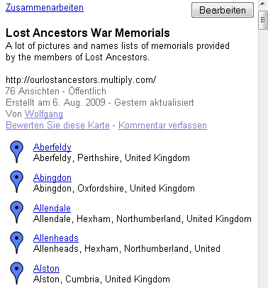
 | Another way to find places and where they are located is given by Google Maps. Click "See where the memorials are located" on each index page of "Members War Memorials" and you are directly leaded to the memorial map. |
 | The page is splitted in two parts. The list of places on the left side . . . |
 | . . . and the map on the right side.
Each memorial or place is indicated by a small blue mark  . . |
 | Each place in the place list is represented by the name, the county and the country. Click the blue marked name. |
 | An information box on the map is opened. Click the blue marked name which is inside of the box and you will be brought to the associated memorial page of "Members War Memorials". Use the backward button of your browser to come back to the map.
But if you like to have a trip into the blue (LOL!) then click one of the blue marks on the map and be surprised which place you hit. An information box will also be opened. |
 | In the upper left corner is the tool for the map navigation located. |
 | The upper circle is for pushing the map to the left and right side but also up and down. Click the arrow for your wished direction.
Much easier is it to do it with the mouse. The map cursor is displayed as a small white hand. Click the left mouse button and the hand becomes to a fist. Keep the left mouse button pressed and shift the map to each side you want. |
 | Some times is it neccessary to have a closer look at the map. The zoom bar helps to resize the map into the size you wish to have. Click the + for zoom-in and - to zoom-out. But it's also possible to zoom with the mouse. Double click the wished place and you will be pushed closer to it.
The small orange man on top of the zoom bar is for entering the street view function. Not possible on each place and not helpful for our war memorials. |
| 
The map bar in the upper right corner of the map makes some more functions possible.
Traffic (Verkehr): Click it and you will get information about density of traffic of specific streets and roads.
More . . . (Mehr . . .) adds different additional informations to the map. For example pictures, videos, webcams . . .
Map (Karte) will show you the version as you got as you entered the site.
Satellite (Satellit) will change your map to a satellite picture.
Terrain (Gelände) adds valleys and mountains to your map. |


